THE DOBROYDE ESTATE
The Dobroyde Estate
formed the present suburb of Haberfield, with well-defined boundaries dating back to the grant to Nicholas Bayley.
Governor Francis Grose originally granted 30 acres of this land to Walter Brody, a convict who was a master blacksmith. It
was known as Brody's Farm. It does not seem that Brody worked or lived on the
land. Brody's grant was later consolidated into the grant given to Nicholas Bayley on the 9th August 1803. This
was a grant of 480 acres, bounded by Long Cove Creek on the east, Iron Cove on the west, and Parramatta Road on the south.
Nicholas Bayley was an Ensign in the NSW Corps, who arrived
in the colony on the convict transport, Barnwell. He held the grant which he called Sunning Hill for about 18
months, selling to Simeon Lord in March 1805, for £850. It is doubtful whether Lord lived on the farm, which he called Dobroyde after
a residence of his mothers family in England. He had considerable property and warehouses in Sydney, and conducted business
in the areas of trading, auctioneering, importing, whaling and sealing, and timber getting. He was also involved in the manufacturing
industry, having a tannery and woollen mill at Botany Bay.
Newspaper reports and advertisements refer to the farm as belonging
to Simeon Lord as early as 1806. In one the farm is mentioned as formerly the property of Nicholas Bayley. Simeon offered
the farm for let in advertisements in 1816 and 1824, suggesting that he did not have an interest in residing there himself.
At some time in the 1820s Lord took out a mortgage on the farm.
The Sydney Gazette of Saturday, 7 December 1816, states: to
be leased for one, two or three years an eligible farm called Dobroyde, situate about 5 miles from Sydney on the Parramatta
Road, comprising 1500 acres more or less, of which about 40 are cleared and divided into paddocks. The whole of the land is
enclosed, being bounded on the Parramatta Road by a ditch and hedge bank and on the other sides by Iron Cove, Long Cove, and
the Parramatta River. On the farm is an excellent villa fit for the reception of a small genteel family with suitable detached
kitchen, dairy, stable, coach house, piggery, cow house and stock yard, together with a most productive garden containing
some of the finest fruit trees in the colony. This farm possesses the advantage of an adjacent run for cattle of about 800
acres on the left of Parramatta Road between the Liverpool Road and Iron Cove, extending to Canterbury and the Cooks River.
Possession may be had on the first of January next.
Lord overstated the size of the land, but would have been close
if adding the run for cattle to that of the farm. In 1824 he advertised the farm for let or sale, but following this he took
out a mortgage on the property, which he transferred in 1826 to David Ramsay.
On 31 March 1825, David Ramsay married Simeon Lord's daughter
Sarah, at St Phillips Church, Church Hill in Sydney. After 2 voyages to New South Wales, David had decided to set up a business
venture with Captain Thomas Raine, and in October 1824 advertised the firm in the Sydney Gazette as Raine and Ramsay.
In her marriage settlement, Lease and Release dated 8/9 March
1826, Simeon deeded the house and farm to David and Sarah Ramsay, protecting the interests of Sarah and any children of the
marriage. Under the terms of the settlement, David Ramsay put up a bond of £4,000 as surety of his intention to repay at 8%
a £2,000 mortgage to Solomon Levy for his father-in-law. The land was released by Francis Williams and Simeon Lord in consideration
of a marriage had and solemnised betwixt the said David Ramsay and Sarah the daughter of the said Simeon Lord, with the payment
of and a five shillings apiece. Sarah Ramsay was to receive and take rents,
issues, and profits, etc freed from the control of David Ramsay. Should Sarah predecease David, he was to have the use
of the land. However on his death the land was to revert to any children of the marriage.
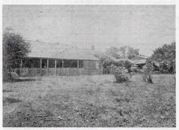
David Ramsay lived at Dobroyde until his death in 1860, and
Sarah continued to live there until her death in 1889. David established a plant nursery, the Dobroyde Gardens, below Dobroyde
House near Long Cove Creek. The nursery was on land left to Edward Pearson Ramsay, but perhaps neglected by him for a time,
as in 1867 Edward P Ramsay advertised the New Dobroyde Plant Nursery.
Always with
an eye to business and investment, towards the end of the 1820s, David had an inn constructed on the Parramatta Road, at its
junction with the Liverpool Road. The inn was known officially as Speed the Plough, but was referred to locally as
the Plough. The inn remained as a landmark for the next 80 years. In Speed the Plough, Ashfield 1788-1988, S and R
Coupe describe it as a substantial two-storey sandstock building with a shingle roof and with a wide verandah on the street
abutted at each end by a single-storeyed wing. In front on either side of the pole bearing its sign stand two horse troughs
carved out of huge logs. David Ramsay did not run the inn, but leased it firstly to Charles Jordan, then to John Ireland,
whose wife took over after his death until 1849. From this time the inn was leased to a variety of proprietors until John
Burrage became the last licensee in 1906.
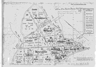
After David's death in 1860, Sarah had a legal document drawn
up dividing the land between the children of their marriage. Mary Louisa had been given a portion of the land in 1855 at the
time of her marriage to Alexander Learmonth, and it was on this land that Mary Louisa and Alexander Learmonth built Yasmar. This document also set the boundaries for the land which was to be conveyed to the Presbyterian Church, for the establishment
of the school, Church, Manse and burial ground. In 1869 the land was conveyed to the Church, with conditions set out for the
preservation of the Vault reserve for the Ramsay family.